Geography of Maaloula
3. Maaloula > 3.3. Geography and Geology of Maaloula
3.3.1. Location:
According to the administrative divisions in Syria, “The city of Maaloula” is the seat of “Maaloula Subdistrict” > one of the “Al-Qutayfah District” subdistricts > one of the districts of “Rif Dimashq Governorate” > one of Syria’s fourteen governorates.
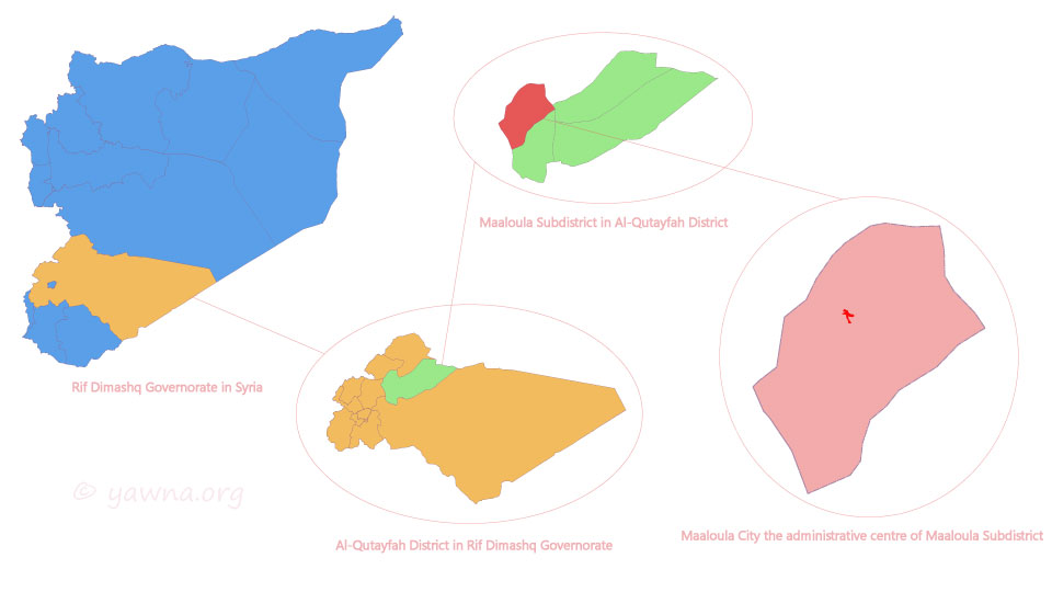
Figure 3.3.1: Maaloula according to the administrative divisions in Syria {© Rimon Wehbi}
Maaloula is 14.33 km (8.9 miles) line of sight from the nearest point of the Syrian-Lebanese border (Tfail lands). While it is 85.2 km (52.94 miles) line of sight away from the nearest point of the Mediterranean Sea (Jounieh Beach).
As for the capital, Damascus, Maaloula is located to the northeast at an angle of 25 degrees, 56 km (34.8 miles) from the center of Damascus, and 54 km (33.55 miles) from Maaloula bus station in Zablatani.
Neighbouring villages:
- ‘en At-Tineh to the south, 3.7 km (2.3 miles).
- As-Sarkha (Bakh’a) to the north, 6 km (3.7 miles).
- Jub’adin to the southwest, 7 km (4.3 miles).
- Aj-Jubbeh to the northwest, 14 km (8.7 miles).
Nearby Cities:
The most important nearby cities that Maaloulians visit to buy some supplies are:
- Al Qutayfah, 17 km (10.6 miles).
- Yabrud. 20 km (12.4 miles).
Geographic coordinates of the main square of Maaloula:
DD (decimal degrees):
- Latitude: 33.844167.
- Longitude: 36.546389.
DMS (degrees, minutes, seconds):
- Latitude: 33° 50′ 39″ N.
- Longitude: 36° 32′ 47″ E.
Time zone:
Maaloula uses EET (Eastern European Time), where the time is two hours ahead of UTC (Coordinated Universal Time) and GMT (Greenwich Mean Time). During the Summer periods, EEST (Eastern European Summer Time: UTC/GMT +03:00) is used.
3.3.2. Topography:
According to the geographical divisions in Syria, “Maaloula Mountain” are located in the first chain of the “Qalamun Mountains” > which belongs to the “Eastern Mount Lebanon Region” > one of the regions of the “High Mountains Region” > one of the eight regions of Syria.
Tectonically, Maaloula is located in the southwestern portion of the “Nabk Anticline” > situated near the “Anti-Lebanon Orogenic Zone” > in the southernmost extent of the “Palmyrides Mountains”.
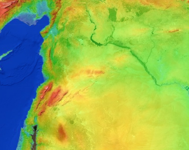
Figure 3.3.2.1: Topography of Syria

Figure 3.3.2.2: Anti-Lebanon Mountains
Elevation:
- The Main Square: 1388 meters.
- St. Thecla Square: 1434 meters.
- St. Sergius and Bacchus Square: 1460 meters.
- The peak of Maaloula Mountain: 1850 meters.
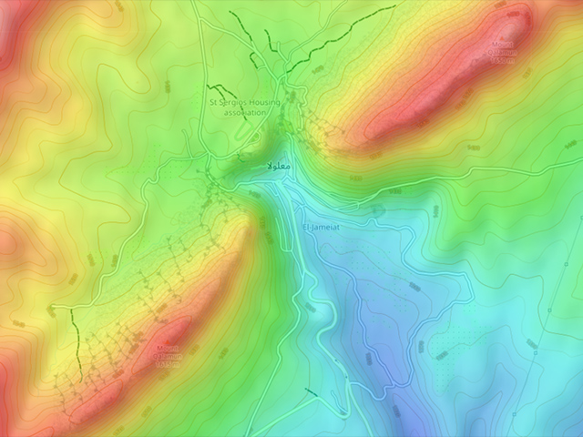
Figure 3.3.2.3: Topography of Maaloula
Area:
The Old Town of Maaloula covers an overall area of about 50,000 square meters.
3.3.3. Climate:
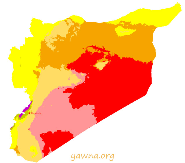
Figure 3.3.3.1: Climate classification map for Syria {Beck, H. et al. Present and future Köppen-Geiger climate classification maps. Edited by Rimon Wehbi}
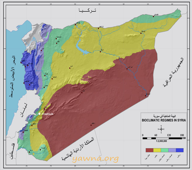
Figure 3.3.3.2: Climate classification map for Syria {Ministry of Defence, Syrian Meteorological Department. Edited by Rimon Wehbi}
Temperature:
The temperature in Maaloula averages 14.7 °C.
The warmest months of the year are July and August. Among the popular proverbs that speak of these two months:
- “بتموز بتغلي المي بالكوز”
- “آب اللهاب”
The average temperature in July is 25.3 °C and the maximum temperature of 32.4 °C, but the higher altitude makes the summer nights cooler. This makes it one of the most famous summer resorts in Syria.
The lowest average temperature of the year is January. Among the popular proverbs that speak of its coldness:
- “بكانون كن ببيتك وكتر من حطبك وزيتك”
- “أبرد من مية كانون”
The average temperature in January is 3.3 °C and the minimum temperature of -0.5 °C.
The lowest temperature in Syria was recorded in January 1951, when the lowest temperature in Maaloula is likely reached -22 °C at night. The second lowest temperature was recorded on January 18, 1973, when the lowest temperature in Maaloula is likely reached -12 °C.
During summer, temperature swings between day and night by as much as 15 °C. While in winter by about 8 °C.
Mean annual temperature has increased by 0.8 °С per century since 1950, and it is projected to increase by 2° С by 2050.
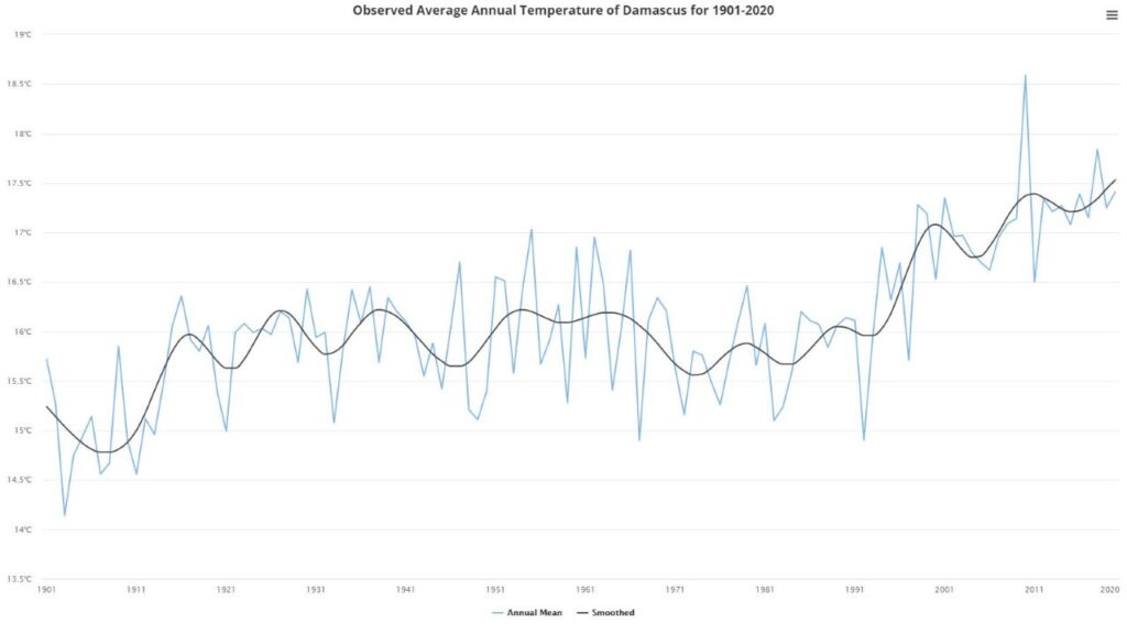
Figure 3.3.3.3: Observed Average Annual Temperature of Damascus for 1901-2020 {World Bank: Climate Change Knowledge Portal}
Precipitation:
In Maaloula, about 147 mm of precipitation falls annually between October and May. Most precipitation falls in January, with an average of 33 mm.
The most famous torrent in the modern history of Maaloula is “The Great Torrent”, that hit the entire Qalamun region on October 29, 1937, taking many lives and destroying many homes.
Maaloula periodically experiences some storms and snowfalls during the winter.
Summer is completely dry.
Mean rainfall has decreased by 18.23 mm/month in the last century. Mean annual precipitation is projected to decrease by 11% by 2050.
Humidity:
The month with the highest relative humidity is January (67.91 %). The months with the lowest relative humidity are June and July (26.87 %).
Wind:
Maaloula is affected by southwesterly winds mostly.
Seasons:
Maaloula is located in the northern hemisphere. Therefore, spring spans the months of March to May, summer spans June to August, autumn spans September to November, and winter spans December to February.
Rimon Wehbi 25/08/2021